Florida is growing fast. New homes go up every month. Shopping centers expand. Roads and drainage systems improve. Because of this steady growth, surveying companies have more work than ever before.
At the same time, something important is happening in the background. Many surveying companies in Florida are joining together. Larger firms are buying smaller ones. Some companies are opening offices in new cities. While this may sound like business news, it directly affects property owners in Fort Myers.
If you plan to build, buy land, divide property, or improve your lot, this trend matters to you.
Florida’s Growth Is Changing the Surveying Industry
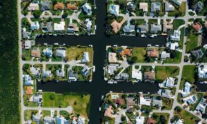
Over the past few years, Florida has seen steady growth. Fort Myers continues to attract new residents and investors. As neighborhoods expand, more land surveys are needed.
Every construction project starts with a survey. Builders need clear boundary lines. Engineers need elevation data. Lenders need accurate maps before they approve funding.
Because demand is high, surveying companies must keep up. Many smaller firms choose to join larger companies so they can handle more projects. By working together, they gain better tools and stronger support systems.
This shift is not random. It is a response to growth and rising expectations.
Why Surveying Companies Are Expanding Now
Several reasons explain this trend.
First, Florida’s development has not slowed down. Homes, apartments, and commercial buildings continue to rise. Surveyors must work quickly so projects can stay on schedule.
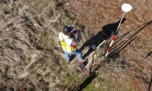
Second, modern surveying requires advanced equipment. Companies use GPS tools, drones, and computer software to measure land with high accuracy. These tools cost money and require regular updates. Larger firms can afford these upgrades more easily.
Third, the profession faces staffing challenges. Becoming a licensed surveyor takes years of training. Many experienced surveyors are retiring. When firms join together, they can share staff and support each other.
Because of these factors, expansion makes sense for many surveying companies.
What This Means for Property Owners
So what does this change mean for you?
You may start seeing new company names in the area. Some firms now serve several counties instead of just one. That can bring both benefits and new choices.
Larger surveying companies often have more field crews. As a result, they can sometimes start projects sooner. They may also use advanced equipment that improves accuracy.
However, busy firms also have full schedules. Because Fort Myers continues to grow, survey calendars can fill quickly. Therefore, property owners should reach out early. Waiting too long can delay permits and construction.
You may also notice changes in pricing. Larger firms may have strong systems and better tools. Still, comparing value matters more than choosing the lowest price. A good survey protects your investment.
Better Technology Is Raising the Standard

One major benefit of expansion involves technology.
Today, many surveying companies use drones to map large areas. They rely on GPS systems that provide precise measurements. They create digital files that engineers can review right away.
In Fort Myers, this accuracy is especially important. Flood zones and elevation levels affect building plans and insurance rates. Even small differences in elevation can change costs.
When companies invest in better tools, property owners receive clearer and more reliable data. That helps prevent problems later in the project.
Local Experience Still Matters
Even though some surveying companies now operate across Florida, local knowledge still makes a big difference.
Fort Myers has its own zoning rules and floodplain requirements. Lee County follows specific permit processes. A company that understands these local details can help avoid delays.
When choosing a surveyor, ask about recent projects in Fort Myers. Experience with local conditions often leads to smoother approvals.
Strong companies combine modern technology with local understanding. That balance protects your timeline and budget.
Choosing the Right Surveying Company
As the market changes, property owners should stay informed.
Start by planning early. A survey should never be an afterthought. Instead, treat it as the first step in your project.
Communicate clearly with your surveyor. Ask about timelines and deliverables. Make sure you understand what the survey includes.
Most importantly, choose a firm that explains results in simple terms. A reliable surveying company does more than measure land. It helps you understand your property and avoid costly mistakes.
Looking Ahead
Florida’s growth will likely continue. Fort Myers remains a popular place to live and invest. Because of that, surveying companies will keep adjusting to meet demand.
Some firms will grow larger. Others will specialize in certain services, such as flood elevation work. Technology will continue to improve.
For property owners, this shift offers opportunity. Expansion can mean better service and stronger support. At the same time, careful selection remains important.
In the end, the growth of surveying companies across Florida reflects the growth of communities like Fort Myers. Development moves forward. Standards rise. Expectations increase.
By staying aware of these changes and choosing the right partner, you can move ahead with confidence — knowing your project begins on solid ground.