How To Find Your Property On FEMA’s Flood Insurance Rate Maps

What are FEMA flood maps?
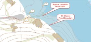
FEMA’s Flood Insurance Rate Maps (FIRMs) or just Flood Maps are provided after a flood risk assessment has been completed or updated for a community.  This study is known as a Flood Insurance Study.  The FIRM gives you the Base Flood Elevations (BFEs) and insurance risk zones in addition to floodplain boundaries.  The FIRM may also show a delineation of the regulatory floodway.

Once the “insurance risk zone”  (commonly referred to as the flood zone) is determined, actuarial rates, based on these risk zones, are then applied for newly constructed, substantially approved, and substantially damaged buildings.  FEMA uses these rates to determine the insurance rate you will pay for flood insurance

FEMA’s Digital Flood Maps

FEMA discontinued the production and distribution of paper flood maps in 2009 as part of its Digital Vision Initiative. This affected all the Flood Maps, boundary information, and study reports. However, clients can still view the products for free through their website or buy them in digital format.

To view these flood maps online, go to FEMA’s Map Service Center and key in your address (hi-lited area shown here) search for your home.  This will prompt you to then select the map that covers your area.  The Flood Maps are somewhat cumbersome to use online. It is best to go through the tutorial on the bottom right of the address search page for an easier and more effective use of the GIS map.

author avatar
Surveyor

More Posts

Surveyors performing an as-built survey with a 3D laser scanner and digital building plans before renovating an older commercial building
land surveying
Surveyor

Why More Commercial Renovations Start With As-Built Surveys

Contractors open the original plans. Then they walk to the building. The two don’t match. A wall was moved ten years ago. A storage room got added after a storm. Someone rerouted a drain line and never told anyone. This happens constantly in Panama City, where a lot of commercial

Read More »
Surveyor reviewing an elevation certificate with a homeowner outside a raised home
flood damage
Surveyor

What an Elevation Certificate Can Show Beyond a Flood Disclosure

Most people only think about an elevation certificate one time. That’s when they buy flood insurance. They glance at the flood zone. Then they file the paper away. That’s a mistake. In Florida, this document holds much more. It has facts that matter to contractors. It has facts that matter

Read More »
Property line markers visible beside a driveway at a home for sale
boundary surveying
Surveyor

Why Property Line Markers Matter More During a Property Sale

Property line markers are easy to overlook. Until a sale starts. Then, every buyer, lender, and title agent wants to know exactly where the lot lines are. Hiring a licensed land surveyor early gives sellers a head start and gives buyers the facts they need to close. This article explains

Read More »
Property owner reviewing a survey map with a surveyor while comparing surveying companies for a land survey project
land surveying
Surveyor

How to Choose Between Surveying Companies in Your Area

Finding a surveying company is not the hard part. Knowing how to compare them is. When you search for surveying companies, you will find plenty of options. The tricky part is figuring out which one is the right fit for your specific job. Two companies can both hold valid licenses

Read More »
Property owner meeting with a land surveying professional while looking for survey companies near me
land surveying
Surveyor

Survey Companies Near Me: What to Check Before You Call

When you search for survey companies near me in Jacksonville, you will get a long list of results. Some have been working in Duval County for years. Others are newer or based in a different part of Florida. The problem is that most listings look the same online. It is

Read More »